A Look Back at New Garden Township’s Roads
Margaret B. Jones, Ph.D.
In 1930, Gifford Pinchot was elected Governor of Pennsylvania for a second term with the slogan, “get the farmers out of the mud.” He saw paving rural roads as an economic necessity for farmers as well as a make-work program for the more than a million unemployed in the State. The roads were to be “economical, but adequate,” and funds were provided to pave 20,000 miles of road. A limited amount of machinery was used so more hand labor would create more jobs. At long last there was to be State Aid so that local municipalities could stone and/or macademize country roads. New Garden Township had a number of “Pinchot roads,” some of which were Hillendale, Penn Green and Landenberg Road.
From the beginning, problems with rural roads were due largely to the policy of making road maintenance the responsibility of local townships. Although farmers were required to work on the roads, they could not be compelled to work more than 6 days a year. “Work” consisted of pushing trees and branches off the roadway, of ditching roadsides for drainage, of filling holes with stone and of rolling the surface. Although there was an elected road supervisor, he had other responsibilities, his farm, blacksmith shop, etc. In addition, farmers’ work was controlled by the weather. If the weather were clear, all their time was spent in farm work and when it rained, neither farm work nor road work could be accomplished. Even after townships were able to tax for road maintenance, farmers were permitted to “work out” their tax bill and many did so. The system essentially did not change.
New Garden’s early roads
Driving the secondary roads of the Township, it is easy to determine which dated from the earliest days of settlement. Steep road banks caused by erosion and repeated digging out of mud mired wagon wheels are the clue. For instance, traveling north on Newark Road from Toughkenamon to London Grove, some of the road banks on the hillsides exceed six feet. In almost 250 years of use before the road was paved, it eroded enough to deepen the road bed by six feet or more.
The history of laying out and building roads was one of need; roads were built from mills to Meeting Houses. And the first roads were only trails marked by blazes on trees. The convention of blazing was 5 notches on a tree, marking a tree about every 100 yards. Newark Road was New Garden Township’s first road, blazed in 1710, extending from Thomas Moore’s mill in Doe Run to New Garden Meeting House. Eventually in 1733, the road was completed to the Delaware line. County records show repeated changes to the original route in: 1721, 1773, 1820.
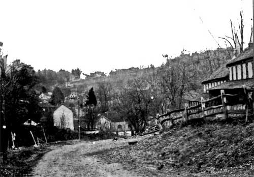
View of Mercer Mill Rd looking
east towards Landenberg
late 19th century
The Township’s other main artery in the Colonial era was the Gap to Newport Pike. In 1752, a petition to the Court in Chester read in part….”to lay out a road beginning at William Miller’s mill….and thence onto the great road which leads to Newport.” This road, beginning on Ellicott road south of Avondale and joining Route 7 which was called the ‘Great Road,” would become modern day Route 41.
Although the blazed tracks of the early roads gave way to dirt roads, many roads were impassable at different times of the year. Letters of protest were published in the local newspapers. In January of 1855, one New Garden resident wrote, “Last week the roads in every direction were in terrible condition for traveling. The frost was nearly all out of the ground and the mud in many places was a foot deep. Occasionally the mud was frozen on top just sufficient to form a crust, which easily permitted a horse’s foot to pass through, but not so easily allowed it to be drawn out.”
Other complaints were with farmers who squared off a field and in so doing, placed a fence across a road, or who, in neglecting to fence their pastures, allowed their cattle to roam over the public road.
By the late 18th century, the process for creating a new road was established by law. A petition for a new road had to be filed with the County Court which in turn appointed a “jury of view” to determine if there was need for such a road. A bond had to be filed by one of the petitioners to cover Court fees and to pay for a survey. The petitioners also had to obtain releases in writing from all landowners involved, to cover claims of damage arising from opening the road on their land. Finally, a drawing of the road, its course, distance, landmarks and names of property owners affected needed to be prepared and filed with the Court. If a road were to be vacated, a similar procedure was followed.
Some of the early petitions for roads in New Garden Township included:
1745 - Penn Green Road.... Road beginning at a black oak within the line of Samuel Miller and ending in the road leading from New Garden Meeting House to William Miller’s Mill.

Southwood Road at the entrance of the James Walker house near the Delaware border, late 19th century.
1807 — Southwood Road….Road beginning at the place where the road leading from Evans’ lime kiln intersects with the road leading from New Garden Meeting House to New Castle, and ending in the State line near the Great Road leading from Newport to Lancaster known by the name of the Limestone Road near the house of Thomas Wilson.
1814 — Ellicott Road ... Road beginning in the new Turnpike Road on the east side of White Clay Creek near the New Garden Township line and ending in the road leading from Benjamin Pusey’s Mill.
1822 — Watson’s Mill Road….Road beginning in a public road near Thomas Brown’s Mill and ending in a public road at the New Castle County line.
1827 - Mercers’ Mill Road…Road beginning in a public road in Chandlersville near the large woolen factory and ending in a public road west of Evans’ Bridge.
Turnpikes
In 1807, the Gap-Newport Turnpike was chartered with stocks sold to shareholders; by 1818, the road was finished at a cost of about $1000 a mile. It followed the old Gap-Newport Road, commonly called the “Grain Road.” Farmers from “up country” had used this road for years to bring their grain to the flour mills along the Brandywine. The road was also a drovers’ road for farmers who drove their cattle and hogs to the port of Christiana for shipment to eastern cities.
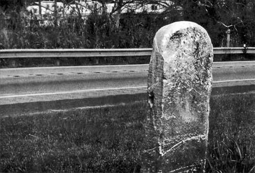
Stone posts to mark the miles
were placed along Gap-Newport Pike
"11 M ro NP" (11 miles to Newport) was etched into this
marker
This marker stands near the Township Building Dept building
Like most of the other turnpikes of the era, the Gap-Newport Pike consisted of a crown or high road of crushed stone and a low summer road of natural soil on either side. The name turnpike derived from the gate or bar which was suspended across the road to stop the traveler until he had paid the toll. Toll gates were built about every 5 miles along the road. Users found the tolls to be exorbitant, and devised schemes to avoid paying toll, such as traveling after 10:00 at night when the gates were thrown open. Examples of tolls were: 4¢ for every 20 sheep; 6¢ for every 20 hogs; 12¢ for every horse and if a rider, 3¢ more; a wagon was 12¢.
Turnpikes were expensive to maintain because of the need for many toll-keepers. Frequently, the income from tolls could not cover road maintenance and toll-keepers’ salaries. By the end of the 1840 era as railroads were being built, most of the turnpikes were taken over by State and local governments; the original stocks worthless. (The Gap-Newport Turnpike Company went bankrupt.) Nevertheless, in the period when farming was moving from subsistence to commercial farming, turnpikes served farmers needing to get their products to market.
A reminder of the turnpike days is the mile marker placed along Route 41 in front of the former township building. This mile marker, originally placed on the north side of the turnpike, was moved to township property for safe keeping.
Paved Roads
With the exception of the Turnpike, stoned in 1818, all other roads in the Township remained dirt roads until in the years 1905-06, Baltimore Pike from Kennett to Avondale was stoned, using crushed stone from the quarry near the present day Tick Tock Day Care Center. This road improvement came about as a result of the Sproul Good Roads Law of 1903 which provided assistance to municipalities for roads. The stretch of road, 15,483 feet long and 16 feet wide cost $20,841; of this amount the State paid $13,894. Newark Road, determined a State road, was paved in 1917.
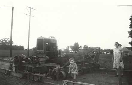
Eddie Cook with his mother along
Rt 41 improvements in 1941
Construction cease4d with the coming of WWII
Gradually as the Township Road Supervisors (precursors to the modern Board of Supervisors) felt they could afford the cost, some of the country roads were stoned and eventually paved. Dirt roads remained the staple for the Township, however, into the mid-20th century. In 1949, residents of Pemberton Road were up in arms because their requests for a hard surfaced road were being ignored by the Supervisors. Residents said no work had been done on the road for 20 years and that at times the road was so muddy and rutted, it was impossible for cars to travel. The same could be said for New Garden Road East which was not paved until the Elementary School was built in 1956-57. It remained another decade before Bucktoe Road would be paved.
Today care and maintenance of township roads remain a local responsibility. The Board of Supervisors employs a fulltime road master and crew for snow removal and general maintenance of New Garden’s township roads.
originally published in The New Garden Lyceum Community Newsletter, Fall 2014